Spatial planning for NZ's renewable energy future
by Emma McRae
The Climate Change Commission’s draft plan, released in January this year, requires rapid expansion of wind and solar power generation in the coming decade to meet electricity demand as our energy needs increase and decarbonisation requires that electric vehicles become more widely adopted.
To meet the draft plan projections, it is estimated that 13 additional large wind farms are needed by 2035. Solar energy is also expected to expand dramatically, with more commercial-scale solar expected to form part of the country’s energy mix.

Emma McRae is a senior landscape architect at Boffa Miskell.
The National Policy Statement for Renewable Electricity Generation 2011 (NPS-REG) currently states (Policy E1) that regional policy statements, and regional and district plans must provide for the development, operation, maintenance and upgrading of new and existing renewable electricity generation activities. In line with this, regional and district plans must now contain objectives and policies which respond to this requirement.
The reform of the Resource Management Act is set to go further than this, with the 2020 report of the Resource Management Review Panel (the Randerson Report) identifying that suitable locations for renewable energy generation should form a national priority as part of spatial planning.
Spatial planning for renewable energy on a national scale has so far received limited attention in New Zealand. The following paper draws on the experience of Wales, a country with a similar sized population, to discuss how spatial planning might assist to plan for these additional large wind and solar farms.

White Hill Wind Farm (Mossburn, Southland). Image credit: Boffa Miskell.
Technical Advice Note 8: Planning for Renewable Energy(or TAN 8, as it is known), published by the Welsh Assembly Government in 2005, set out to identify areas within Wales where large scale (over 25MW) wind developments could be accommodated.
TAN 8 identified seven Strategic Search Areas (SSAs) considered to be unconstrained areas capable of accommodating large-scale wind developments. TAN 8 did not specifically contain guidance in relation to solar development but outlined that proposals should be supported for appropriately designed schemes, with the exception where visual impact is critically damaging to a listed building, ancient monument or conservation area.
The SSAs were identified as areas capable of delivering the Welsh Assembly Government’s renewable energy target of 4TWh by 2010. The fundamental objective in defining the SSAs was to ascertain the most appropriate areas of Wales in which to locate 800MW of onshore wind turbines minimising direct land take. The SSAs were identified as “relatively unconstrained” areas according to nominated criteria and excluded areas with nationally or internationally recognised designations.
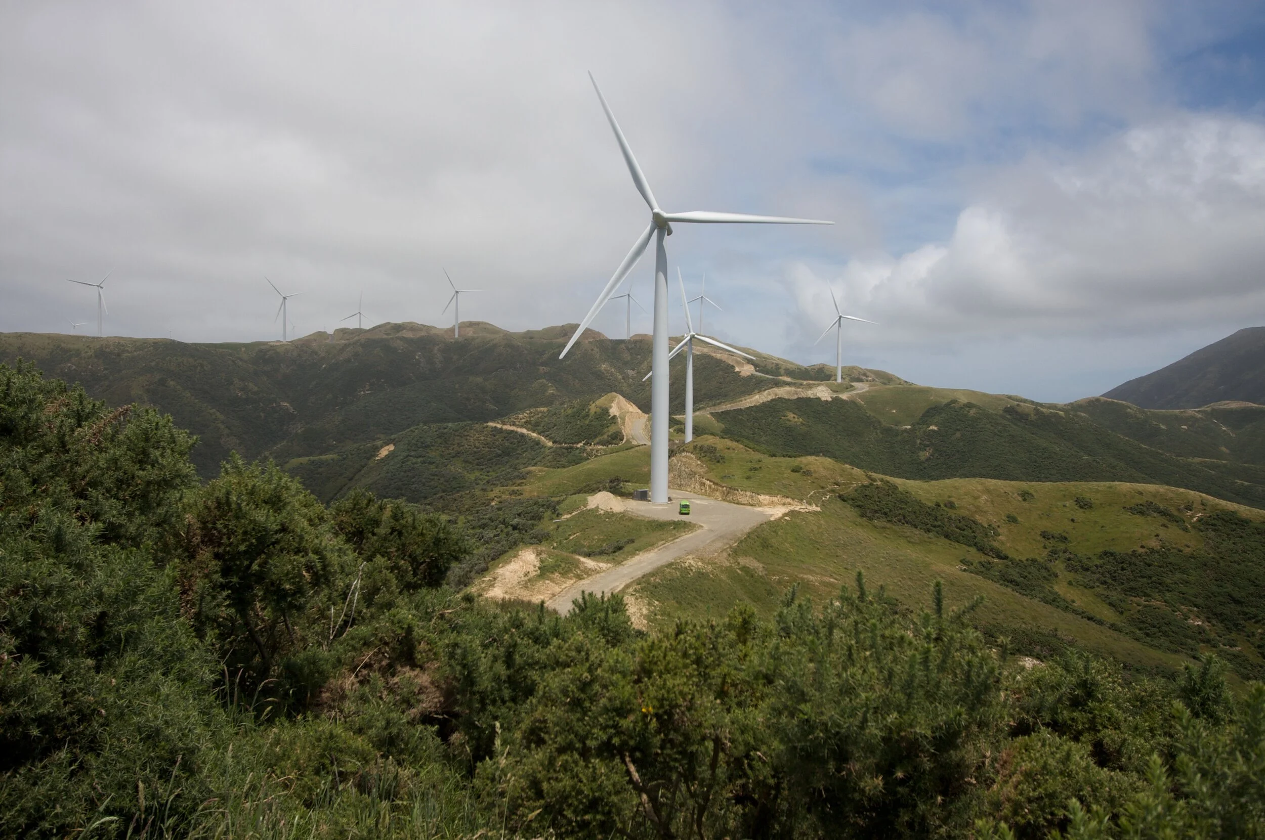
West Wind (Makara, Wellington). Image credit: Boffa Miskell.
Consultation on the draft of TAN 8 was critical of the treatment (or lack thereof) of landscape and visual issues, and cumulative impacts. However, a report commissioned following the release of the draft SSAs concluded that landscape, visual and cumulative issues could not be criteria and excluded areas with nationally or internationally recognised designations.
Consultation on the draft of TAN 8 was critical of the treatment (or lack thereof) of landscape and visual issues, and cumulative impacts. However, a report commissioned following the release of the draft SSAs concluded that landscape, visual and cumulative issues could not be addressed satisfactorily at an “all Wales” level, and these issues were best addressed at a local or regional level (Welsh Assembly Government Facilitating Planning For Renewable Energy in Wales: Meeting the Target Review of Final Report (June 2005).

West Wind (Makara, Wellington). Image credit: Boffa Miskell.
The seven SSAs identified in TAN 8 were at a “broadbrush” scale. Not all of the land contained within each area was technically, economically or environmentally suitable for wind farm development, and it was a matter for local authorities to assess the detailed locational requirements for the siting of onshore wind developments and refine SSAs where appropriate.
Local authorities had the authority to assess applications for wind projects of under 50MW; those over 50MW were considered Nationally Significant Infrastructure Projects(NSIPs) and referred to the Planning Inspectorate agency.
In 2015, the Planning (Wales) Act introduced a new category of planning application: ‘Developments of National Significance’. This covered large-scale infrastructure projects of national importance and removed onshore wind projects from the NSIPs process and devolved energy consenting to Wales.
A 2018 review of TAN 8 found a shortfall in the capacity of operational wind farms within SSAs. TAN 8 capacity targets were based upon turbines generating 1.5 to 2 MW, however progress in turbine technology enabled turbines with much greater capacity; this meant that the capacity of turbine schemes, either consented or in planning, in 2018 far exceeded the 800MW target set out in 2005.
However, many of the consented projects identified in the review did not actually progress to construction. Several schemes did not gain consent, despite being located within SSAs, with public opposition to turbines a contributing factor in the decisions. Grid capacity was also an issue where SSAs were located in remote areas.
A proposal for high voltage towers connecting proposed wind farms in Powys, mid-Wales, through several areas with sensitive landscape and historic values faced strong local opposition.
In 2015, the Department of Energy and Climate Change refused planning consent for four proposed wind farms which would have used the connection, and work on the project was suspended. Nevertheless, the 2018 review identified that pre-TAN 8, there was 298MW of operational wind power, and post-TAN 8, this had risen to 701.8MW.
Of this, 136MW lay outside the SSAs. In February 2021, following release of a draft in March 2019, the Welsh Government published the new national development framework ‘Future Wales – The National Plan 2040’, which is the first national spatial plan for Wales, and the 11th edition of Planning Policy Wales.
This new planning policy document replaces TAN 8 and the SSAs. Eleven new ‘Pre-Assessed Areas for Wind Energy’ are identified, based on a methodology which included stakeholder workshops with representatives of local planning authorities, distribution network operators, transmission operators, National Parks and Natural Resources Wales. Constraints and opportunities relating to technical issues and other environmental issues, as well as cumulative impacts and wider benefits were considered and used to develop an analysis tool to define the areas using ESRI’s software ArcGIS Enterprise.
The Welsh Government’s background report (Assessment of onshore wind and solar energy potential in Wales: Stage 1 – Development of Priority Areas for Wind and Solar Energy (7 March 2019) which identified the initial boundaries of the 11 ‘Pre-Assessed Areas’ also originally identified priority areas for solar development, however these were not carried through to the spatial plan.
The mapping of the Pre-Assessed wind areas is designed to be read at a national scale, with further assessment required to identify suitable sites. Within such areas, there is a presumption in favour of development of wind energy, subject to meeting policy requirements in relation to visual, ecological, heritage, amenity (in the Welsh context this refers to noise, shadow flicker etc), defence or transport interests.
More supportive policy within the ‘Future Wales’ framework for renewables also gives reference to solar schemes but without identifying specific areas.
The Welsh experience identifies that a methodology for identifying areas for future renewables development must be based on criteria that take into account renewable energy sites and their connection to the wider electricity network.
Landscape characterisation provided one of the elements used to define the 2019 background report’s ‘Pre-Assessed Areas’, but it was not used in the first stage of the assessment back in 2005 to define the SSAs, which only excluded areas with agreed national and international designations.
Landscape characterisation identifies and describes the combination of elements and features which give a landscape its distinct character. In Wales, this is provided by the Welsh LANDMAP system, which identifies areas relating to five attributes – Visual and Sensory, Landscape Habitats, Geological Landscape, Historic Landscape, and Cultural Landscape, each acting as an overlapping layer with values assigned for each aspect.
This story is republished with permission of the Resource Management Journal. You can read more here.