Kakadu in ‘Knock em down storm’ season
Contributed by Robin Simpson - Robin Simpson Design
In the 25 years of my urban Sydney life, I hadn’t ventured to the Far North of Australia. It took a return to Aotearoa New Zealand and the company of an intrepid traveler before I found myself driving on the Arnhem Highway, the road to Kakadu.

Looking east over floodplains to the Arnhem Land escarpment. (All images courtesy of Robin Simpson).
Driving from Darwin into Australia’s Kakadu National Park, with green bands of wetland stretched north and south, ahead to the east rises the 300m high Arnhem Land Escarpment, some of the oldest exposed rock in the world. The seeming simplicity of wet plains and drier stone country contrasts with my increasing awareness of the landscape’s actual complexity.
The Kakadu National Park is leased by the Traditional Owners, the Bininj/Mungguy people, to the National Parks Service who administer it at a Federal level. The Kakadu Board of Management, which has an Aboriginal majority (16 out of 21 members), representing the Aboriginal traditional owners of land in the park, was established in 1989.
All 19,804 km2 of the national park have been a UNESCO World Heritage site for 44 years, in acknowledgement of both its extraordinary natural and cultural landscape (something it uniquely parallels with the Tongariro National Park). The lowlands, forming 80% of the national park’s area, are protected by the RAMSAR Convention on Wetlands.
Kakadu has six different seasons; three are drier and three when the floodplains are filling, full or emptying. Though we were visiting during 'Knock ‘em down storm'”' season, we mainly had blue skies. The late start of the last monsoon season meant that the flood waters had only dropped a meter, with three to four meters still to drain.
Many roads were closed and locations inaccessible while the pools of water were still obvious under the trees and across the grasslands. As the crocs had moved upstream with the flood waters, warning signs about them were common, often in surprising places.

It is Old
Obviously, a national park is a recent, western construct while the Country has been part of the ecology for a very long time. Some literature cites evidence of 65,000 years of occupation. For the Bininj/Mungguy people their lives on this land began during the Creation, when ancestral beings created features, landforms, plants, animals and people.
Since then, the Bininj/Mungguy people have developed a fine-tuned knowledge of successfully living in this environment. Their detailed understanding of food sources, seasonal changes, harvesting techniques, and complex food preparation has passed down during ceremonies and food-gathering expeditions.
Moving through the landscape in response to seasonal changes, they’ve used fire to enhance the environment for future visits.
Aboriginal traditional knowledge of patch burning is now current practice in Kakadu. Small fires, which burn fast in focused areas encourage biodiversity and guard against hotter, more destructive wildfires.

Diverse regeneration after fire managed by patch burning.
We observed hazy plumes in the distance and passed by small groups of the Bininj/Mungguy burning areas as small as 20m2. Trees wear the black cloaks of older fires, though most refresh through extraordinary adaptations such as shedding bark, sprouting from underground roots and epicormic buds.

Seasonal bark shedding of some Eucalyptus sp. reduces fire load.

Paint a Picture
The dreamtime stories of the the Bininj/Mungguy people synthesise the spiritual/cultural/landscape into one and synchronise the past with the present. This is graphically portrayed in Kakadu’s 5,000 rock art sites.
This rock art offers “a continuous temporal span of the hunting and gathering tradition from the Pleistocene Era until the present. While these sites exhibit great diversity, both in space and through time, the overwhelming picture is also one of continuous cultural development.
Certain sites are restricted, so powerful they’re only allowed to be seen by a select few, while other sites welcome visitors.

Geology of Burrungkuy Rock an ancient Aboriginal shelter rich with drawings.
We walked into the Burrungkuy Rock Shelter, under one of the Stone Country outliers. For 40,000 years it had been the wet season residence of Aboriginal clans who met here, swapped stories, undertook ceremonies and lived from the nearby waterways.
The soft pinks, creams and yellows of the banded rock first caught my eye. These were astonishing, but a closer view showed artworks that were beyond astonishing.
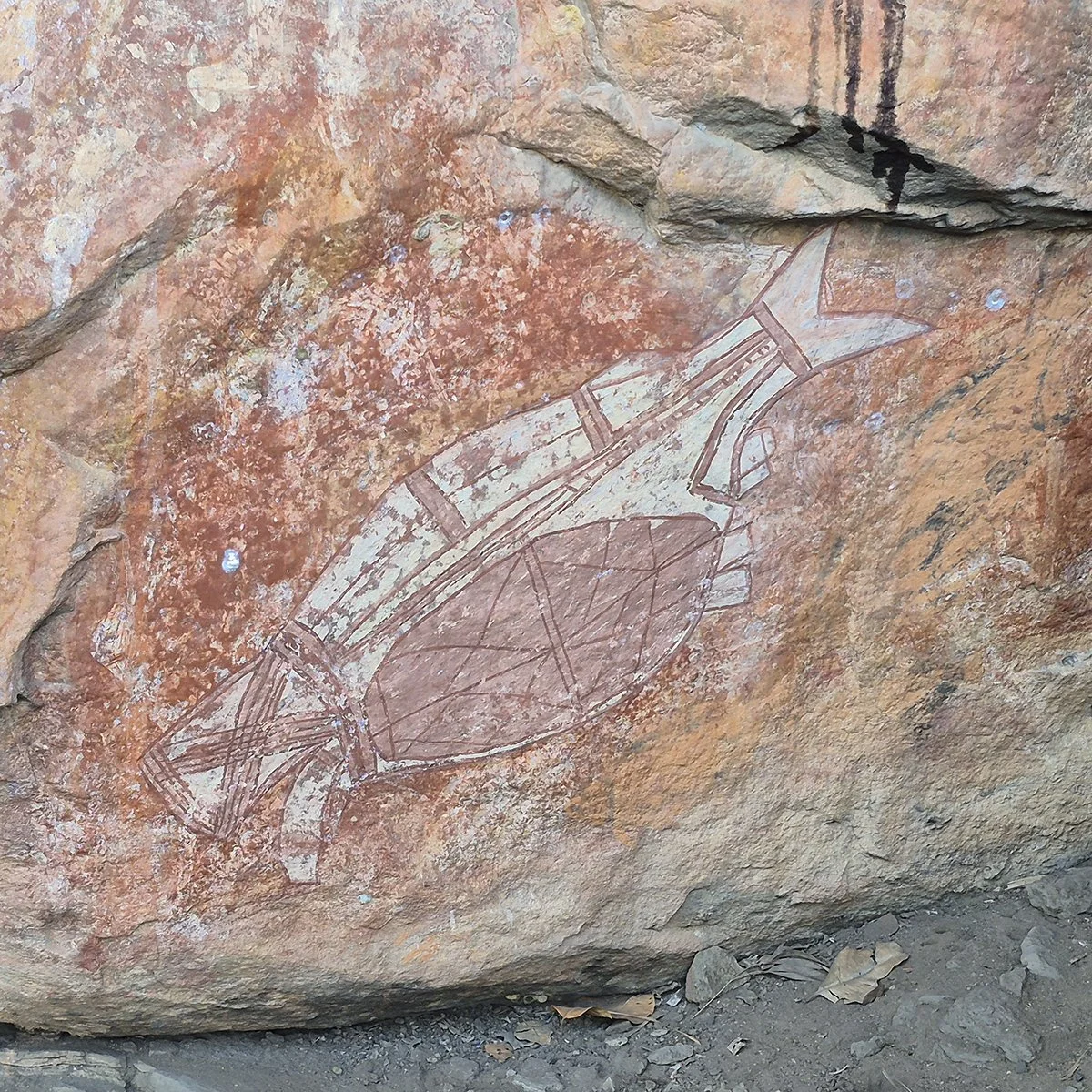
Rock art at Burrungkuy Rock shelter. Drawings in ochres overlaid over time.
Layers of ochre linework communicate knowledge and law - six fingered Mimi (ghosts) to European sailing ships arriving, to fish and turtles.
One story depicts the incestuous lovers who were turned to rock for breaking taboo. Another character is Alkayhko, the Fire Woman, with four arms and plants sprouting from her head, who spread the genus Banksia as she moved across the land.
Driving about, we frequently saw closure signs; “road closed for wet season” or “road closed for cultural reasons”. Were these the same thing, in a place where landscape and culture are inseparable?

Our venture
I observed a landscape that was beautiful, powerful in its diversity of ecosystems and species, and nuanced in responses to minor changes in slope or moisture.
It is no walk in the (Tongariro) park however, with top predators (Saltwater Crocodiles) dominating, snakes silently accompanying every walk, insects swarming and biting en masse, plants pricking or poisoning and heat threatening the lives of the unwary.
Visitors are welcome to this Country. Jacob Nayinggul of the Manlakarr Clan invites:
“Our land has a big story. Sometimes we tell a little bit at a time. Come and hear our stories, see our land. A little might stay in your hearts.”
But locals, who live within the park, want to have their own lives. Visitor information at the Burrungkuy Rock Shelter site affirms:
“We give these sights for visitors to enjoy while we live elsewhere….”.
The wetlands are internationally recognised as significant habitat for migratory birds.

Melaleuca and Pandanus spp. overhang still waters at Yellow River.
We took a dawn cruise on the Yellow Water Billabong, to watch for them. The captain’s briefing was simple – “don’t let any part of your body extend outside the boat”.

Yellow River Billabong. Water Lilies are important food sources.
Basking and swimming crocodiles offered powerful reinforcement. We quietly slipped beneath overhanging Melaleucas which, in the next weeks, would become further exposed as the vast flood plain drained. Broad flat waterlily leaves, and rafts of Eleocharis or Pandanus, harnessed the surface tension, rising and falling with the water level.
This network of river channels is visited seasonally by over 60 species of birds: one third of all bird species in Australia.
We spotted eagles, night herons, egrets, spoonbills, whistling ducks, kingfishers, jabiru and more. None were more enchanting than the chicks of the jacabina, the Jesus Bird, with feet bigger than their bodies, weightless fluffballs atop gangly legs, skipping across the waterlily leaves.
As we drove southwest and out of Kakadu, into more hilly, treed savannah, I felt changed by my visit.

Tropical Savannah with wild sorghum understorey.
I could look past the dreadfulness of newly hatched termites swarming our headlights and the sudden emergence of large green frogs from under the toilet seat. These were moments of both horror and mirth.
I could recall the moments of Kakadu that felt ageless. The sheer beauty of the whenua and the exquisite rock drawings and other artworks, that articulate the liminal space between the past and the present, the humility of being in the vast landscape.
I felt honoured to have been there.
Sources and further reading
Kakadu National Park. Australian Government.
Kakadu National Park Visitor Guide. Australian Government, Parks Australia and World Heritage.
Boggy Plain: Indigenous engagement in Fire Management. Charles Darwin University.