Astute perspectives from the world of data science
Wellington-based company Dragonfly Data Science popped up on LAA's radar when it was in the news for its quickfire surfacing of before-and-after satellite imagery showing the devastating extent of landslips and silt damage after extreme, highly localised storms on the East Cape earlier this year.

Dragonfly’s Finlay Thompson
As Dragonfly director and chief executive Finlay Thompson sees it “satellite imagery should be viewed as a crucial response tool in the aftermath of any disaster. It's needed as soon as possible, so it's a case of not letting the perfect get in the way of the good".
He's an advocate for releasing tools and planning needed to gauge the impact of events like this more regularly and a big believer in the power of open data for getting information into the hands of the people who need it.
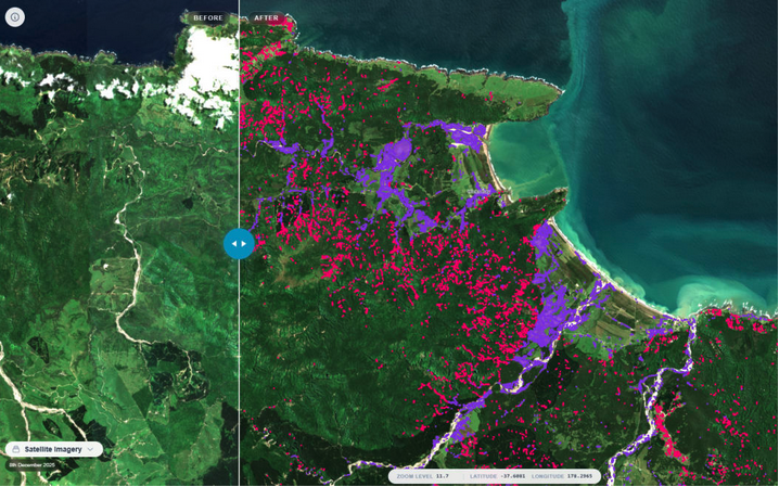
Dragonfly's snapshot mapping revealed more than 11,000 landslips and silt damage covering 900 hectares across the East Cape following a January storm. Photo: Dragonfly Data Science
Finlay says the mapping helps to bridge the gap between disaster response and long-term climate preparedness, adding that “by linking storm impacts with rainfall and terrain data over multiple events, we could begin to build models that help predict where slips and flooding are most likely to occur in future.”
He acknowledges that mapping for an urban environment, where isolated slips have significant impacts, would need much more granularity, that is below 10 square metres.
In February 2023 Dragonfly had also done an initial snapshot of flooding caused by Cyclone Gabrielle in the Hawke’s Bay, supplemented with information on the extent of slips and silt. That was then followed in 2023 by work with the Social Wellbeing Agency on producing an interactive map of cyclone impacts overlaid with infrastructure and demographic data.
Doing Good With Data
Finlay has been with Dragonfly since 2008, joining as its first employee two years after it was founded by Edward Abraham.
The company is a member of the Independent Research Association of New Zealand (IRANZ), and as it enters its 20th year it now has 20 staff, described on the Dragonfly website as “a team of physicists, biologists, maths geeks, programmers and communicators who care about doing good with data”.
As well as other public good projects and work aligned to the climate change resilience of forests, Dragonfly’s portfolio features many projects related to biodiversity, wildlife and marine environments.
Those include the likes of:
Koala population modelling in southeast Queensland
a seabird risk assessment for MPI
modelling of marine predator-prey relationships
analysis of pāua fisheries
mapping turtle distribution in the Pacific
creation of an integrated population model and app for the Department of Conservation to allow effects of different threats facing the Antipodean albatross population to be explored.
Given the broad range of projects that Dragonfly works on with end users, Finlay is comfortable describing himself as a ‘generalist’, and says a large part of the work is about looking for, seeing and re-seeing patterns.
In a wide-ranging conversation with LAA, it was quickly apparent that Finlay already knows more than a thing or two about topics like land cover and land use, as shown when discussing his interest in work by the office of the Parliamentary Commissioner of the Environment (for example its report on the Land Use Capability system) and work done by agencies like the Environmental Protection Authority Te Mana Rauhī Taiao and Ministry for the Environment (soon to be absorbed into the new Ministry of Cities, Environment, Regions and Transport). Indeed one of Dragonfly’s past projects with the Ministry was implementing a data system for monitoring consenting and resource management activity.
Finlay also offered astute perspectives on issues related to ‘altered landscapes’ such as the Marlborough Sounds, and a general awareness of the proposed changes contained in the Planning Bill and Natural Environment Bill “where the definition of exceptions – be that baselines like outstanding natural features or what constitutes ‘more than minor’ – becomes the whole thing”.
Its subject matter that he’d welcome more explanatory information on, particularly as the onset of spatial planning as a key component of the proposed new planning system gathers pace.
See also: