Ngā Ūranga ki Pito-One. A relationship reclaimed.
Words and pictures by Ralph Johns
Sometimes people grow apart. What was once a unique bond becomes slowly and imperceptibly, more detached. Eventually, after a long silent drift, what remains of the relationship is obscured by emotional distance and physical disconnection. We find ourselves living parallel lives, and as much as you try you cannot reach across the void to connect with each other anymore. The relationship is lost, and sadness lingers.
The same thing happens with places. Incremental development, changing ownership, utility upgrades and expanded transport infrastructure can erode both structural and emotional connections and lead to an estranged relationship between landscape and community. Places that were once lived in and known intimately become obscured and inaccessible.
Yet this idea of separation reflects a Western worldview. In Te Ao Māori the relationship between people and place is not something that can ever truly be broken. Even though access might be severed and ownership lost, the ancestral relationship with the whenua remains.
A stretch of coastal edge along Te Whanganui-a-Tara, Wellington's great harbour, has been stuck in a state of dissociation, hidden in plain sight.
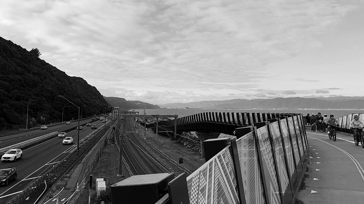
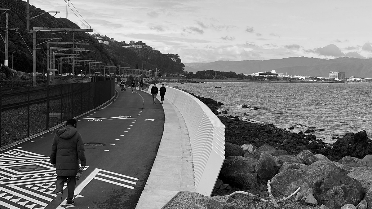
The constrained movement corridor between the Hutt Valley and the capital—one of the busiest in the country—had become completely filled with the railway, state highway and utilities. Efficient connections had taken primacy over history, nature and public access, leaving the harbour’s edge inaccessible. The human relationship between the land and sea had vanished.
Te Ara Tupua was conceived as an active transport project that would link the cities of Te Whanganui-a-Tara, Wellington and Te Awa Kairangi, Lower Hutt along this coastal corridor. To be delivered in three sections, the middle part was always going to be the most difficult, running along the harbour edge between Ngā Ūranga and Pito-One.
After wave action from a southerly storm in 2013 left train tracks suspended in the air, what started as a project to deliver a safe walking and cycling connection evolved to also become a coastal resilience project. A combination of seawalls and embankments would protect the infrastructure from coastal erosion and provide the foundation for the shared path.
Looking back to the creation stories of the great harbour and the people who lived in a string of settlements around it, the cultural impact assessment documented forgotten place names, hidden associations and stories of significant local chiefs.
Mana whenua recalled what was lost and envisioned what could be reclaimed. By working in partnership, the New Zealand Transport Agency Waka Kotahi and the project team were able to listen deeply and ensure that this indigenous local knowledge was instilled into the project. Mātauranga Māori was embedded at all levels, while the Mana Whenua Steering Group ensured that deeply held values were supported and maintained throughout the lifetime of the project.
The ambition was brought together in a Cultural and Environmental Design Framework that carefully integrated the shared path with the ecology, natural character and sites of cultural significance. That the completed work bears such a striking resemblance to the words and images contained within the consented design framework is a testament to all those who held the vision through the years, from consenting to construction.
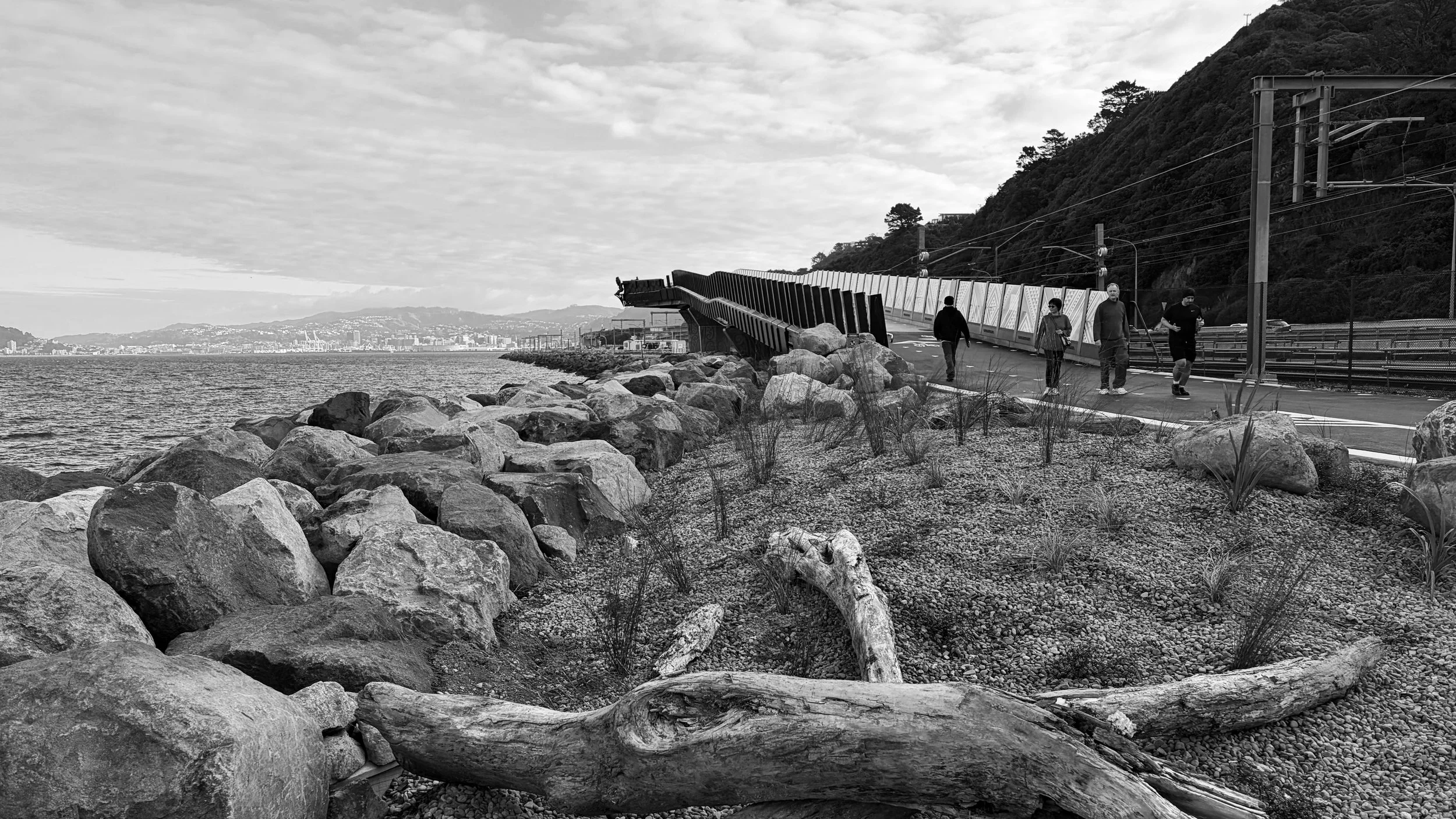
During Te Ara Tupua Alliance’s detailed design process many complex engineering challenges had to be resolved while also minimising environmental impact and controlling project cost. A major innovation supplemented the revetment rock—boulders from Rotorua, Taranaki and Golden Bay—with interlocking concrete Xbloc units that allowed for the construction of a steeper slope, minimising potential impact on high-value marine habitats. This design also enabled the project to stay within its consented footprint.
Additional innovations were designed into the revetment to accommodate terrestrial and marine life. Care was taken to create habitat for little blue penguins (kororā), shags (kawau), and other endemic seabirds, as well as giving sea-life spaces to thrive in tidal pools, nooks and crevices. A special Xbloc unit was customised, in collaboration with the iwi design lead, with textured surfaces that mimic the natural rocky foreshore to create an environment that encourages the growth of marine plants. Just offshore, artificial reefs offset the loss of marine habitat by providing a home for algae, seaweed, crayfish, shellfish and kina.
Other cultural elements were developed and integrated into the overall design to honour the history of the land and people. Where the curving bridge that straddles the railway line opens out to face the harbour there is a space to pause, enclosed by a remarkable balustrade that looks like it has been carved out of solid bronze, on the other side of which the solid figure of Te Wharepōuri leans out toward Matiu Island, as if on the prow of a waka.
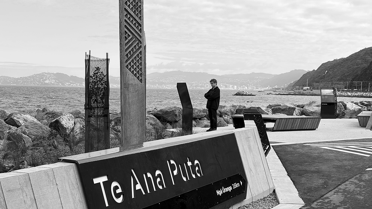
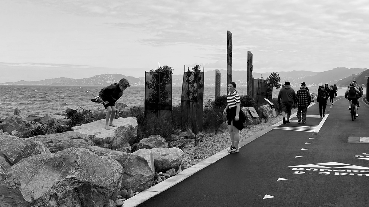
Six ūranga, landings or rest areas, were incorporated into the pathway to both encourage appreciation of the natural and cultural history of the coastal landscape and create a more naturalised coastal edge. The location and form of each ūranga relates to the underlying geology, and each has its own character and brings back lost names of significant places, people and stories: Piki Wahine, Tahataharoa, Parororangi, Pari Kārangaranga, Te Ana Puta and Horokiwi. Anchoring the pathway at Pito-One is Honiana Te Puni Reserve where the constrained coastal edge opens up into the wide flood valley of Te Awa Kairangi. Here another epic bronze taonga named Te Kaiurungi o Te Puni represents the stern post (taurapa) of the waka.
There comes a time with every public project when, after years of anticipation, the construction fences are taken down and the community are invited in.
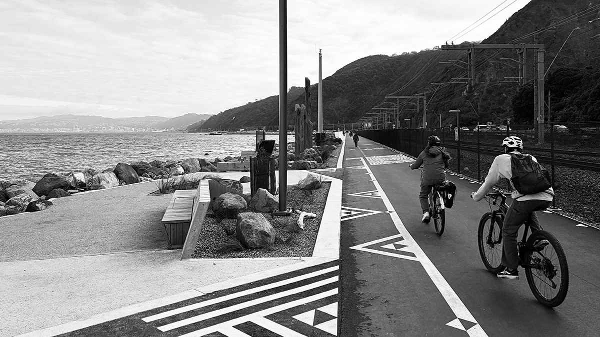
Early on a Saturday morning in May, after the speeches and ribbon cutting of the previous day, I watched as people started to flow along the path, on foot and by bike. Lone cyclists and runners at first, then couples, families, dog walkers, groups of runners, ebikes and road cyclists. People on scooters and skateboards. Fishing rods. By mid-morning the trickle had become a flood, and it seemed for a moment that everyone I knew was there.
Museum and exhibition designers talk about ‘streakers and strollers’ to describe two distinct visitor types categorised by both their attention spans and walking speeds. While streakers breeze through and gather quick impressions, strollers take their time, pausing to consider all the information and contemplate the details.
The same thing works for public spaces. Ngā Ūranga ki Pito-One rewards both the late-night cyclist aiming to beat their Strava PB, and the considered and curious morning walker keen to ponder upon the ecology and soak up the blue-grey harbour views. And it works for everyone else in-between. Like a great movie or a music album, the experience rewards multiple visits—except in this case, the number of possible experiences is infinite given the ever-changing nature of the light, the mood and texture of the harbour, and the direction and intensity of the wind or rain.
Thanks to this 4.5 kilometre long shared path, it is now possible to safely walk and cycle between Lower Hutt and Wellington.
It is a great thing when an Infrastructure project makes people genuinely happy, when they say it changes how they live their lives, and that it seems to make the whole community feel proud.
On that opening morning, we were smiling because of the excitement of rediscovering the harbour from a new perspective. We were smiling because of the sheer joy of gliding along a smooth, wide asphalt surface next to the sea. We were smiling because we saw our history, culture and values expressed in the names, artworks, plants and materials. We were smiling because Wellington has been a bit downtrodden lately, and this feels like a thoughtful and unexpected gift.
Reclaiming relationships takes time and commitment. Finding each other again is a case of looking back before moving forwards, remembering what was valued, trying to revive those connections and feelings—and hoping that there is a strong enough foundation to build back from.
Ngā Ūranga ki Pito-One has been built upon solid rock; greywacke uplifted by plate tectonics and eroded by the sea. The unique inter-relationships between topography, ecology, culture and people have been brought back to life through meaningful partnership, careful planning, innovative design and collaborative construction.
It’s been a long and emotional journey. Continuity has been restored and we can now collectively enjoy the elated excitement of a relationship reclaimed.
A relationship between two communities, between people and the harbour edge, and between the present and the past.
Project Note
Ngā Ūranga ki Pito-One is a benchmark for resilient infrastructure combining active transport, cultural expression, ecological restoration, placemaking and climate resilience.
It was delivered by Te Ara Tupua Alliance: NZTA, Downer NZ, HEB Construction and Tonkin+Taylor in partnership with Te Āti Awa Taranaki Whānui ki te Upoko o te Ika and Ngāti Toa Rangatira who appointed cultural designer Len Hetet. Sub-consultants included S&T, Holmes and Isthmus. Names gifted by Kua Moeahu. Whakairo (carved elements) by Sam Hauwaho and team at Artek Ltd. Bronze Structures by the team at Heavy Metal Company.
Te Ara Tupua was joint winner of the Transportation Project of the Year Award at the Sustainability Delivery Awards in 2025.